.png)
Seven hiking and adventure ideas for Chinese New Year in northern Taiwan!
- The Cartographer

- Feb 6, 2021
- 7 min read
Updated: Apr 27, 2024
UPDATE: We have published a series of full, much more detailed articles for each of the hikes below. They include much more easily downloaded GPX files, detailed maps and more. Check them out!
*Please note that The Map Room participates in the Amazon Associate Program, and other affiliate programs, and may earn from qualifying purchases at no extra cost to you.

10% discount on Parkbus Taiwan! Click the link and enter the discount code MapRoom10 for a 10% discount on Parkbus Taiwan rides!
The Map Room has an affiliate arrangement with Parkbus Taiwan and will receive a commission if you do. We stand strongly by our affiliates, because at the end of the day, they help get us safely to the end of the day.

Click the link above to get 20% off a year-long, premium Gaia GPS subscription! The Map Room has an affiliate arrangement with Gaia and will receive a commission if you do... but we ONLY recommend products that we have tested, used, and loved in the field ourselves! We stand strongly by our affiliates because, at the end of the day, they help get us safely to the end of the day.
Hikes in the series:
Fire Mountain (火炎山) Novice
Five Finger Mountain (五指山) Beginner
Gaotai Mountain and the Three Daotian Peaks (高台山 - 小,中,大岛田山縱走) Low intermediate
Jiali Mountain Part I: There and Back Again (加里山) Intermediate
Jiali Mountain Part II: The Jiali Mountain - Hakani Mountain Loop (加里山 - 哈堪尼山縱走) High intermediate
Or, see the whole series at this link!
Looking for somewhere to hike during CNY? Well, if you live in northern Taiwan - especially Hsinchu - here are seven ideas for you!
Just a quick note before reading on: I'm generally a VERY fast hiker, and some of the GPS routes below reflect that. I've noted which ones I was pushing hard on, and when I was taking it easy.
These are quick outlines of some of my favorite, go-to weekend hikes. I hope to get back to each one soon and add pictures and do a much more detailed write-up, including how you can use these to go from no hiking experience to ready to challenge your first major peak by using them as sort of a self-guided course of study, but for now, here are the bare-bone basics.
First, and easiest:
Fire Mountain (火炎山)
Length of hike: 6.4 km
Time: 2 hours 20 minutes at a leisurely pace taking pictures
QR code for the route:

Remarks:
As dramatic and beautiful as it sounds, this is an easy hike that took us minimal effort in exchange for amazing views! I can't put the view into words, but luckily, our fellow Map Room explorer, Johan, has recently made an excellent video showing it in its full grandeur!
Second, and one step harder: Five Finger Mountain (五指山)
Length of hike: 6.67 km IF you take in the sixth peak.
Time: Though we took over 5 hours, we were also going at a very beginner level, relaxed pace - and we took in a sixth peak in the process.
QR code for the route:

Remarks: There's also a really cool section with a beautiful slot between two rocks, framing a ribbon of sky high above you. It's not to be missed! (Google Maps link with pics)
Third, and one step more difficult: Gaotai Mountain and the three Daotian Peaks (高台山-小,中,大島田山回來)
Length of hike: Part 1: 1.6 km. Part 2: 5.4 km. Part 3: 1.6 km. Total: 8.6 km.
MY Time: Part 1: 52 minutes. Part 2: 2 hours, 9 minutes. Part 3: 45 minutes. MY total: about 3 hours, 45 minutes. IMPORTANT: I am very fast, and I was moving fast. I advise planning more like 5-6 hours total for this. Better yet, leave early in the morning, dedicate the day for it, and come back in the evening.
Google Map links to the trailhead 1 and trailhead 2 (I recommend 1 for larger vehicles, but 2 if you're on something small like a scooter.)
My GPS track link parts 1 and 3 (parking area - flat a
rea just past Gaotai Mountain)
QR code for the route:

My GPS track link part 2 (flat area to Big Daotian and back)
QR code for the route:

Remarks: This is a beautiful hike through pine forest up to a low peak with a gigantic tree that you can climb up into and get some great pictures. As I said above, I'm a VERY fast hiker, so do take that into consideration when planning your times!
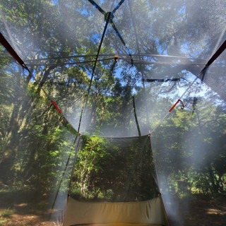
You can also camp here at the flat area just past Gaotai Mountain if you want. It's one of the nicest easily accessible campsites I know in Taiwan - though it's gotten pretty popular recently, so there may be crowds. You can usually beat them by getting there and pitching your tent in the morning.
Fourth and fifth, and one step more difficult still: Mount Jiali / Jiali Shan (and the optional extension to Hakani Mountain / Hakani Shan) 加里山 (- 哈堪尼山) 回來
Jiali Mountain up and back only:
Length of hike: 13.4 km
Time: roughly 6-7 hours up and back
QR code for the route:

Remarks: This is a nice, beautiful hike up a broad, well-maintained, manicured trail. Don't let that put you off of it though - it's worth it for more serious hikers as well! Beautiful pine forests, mossy boulders and good views from the peak of the central mountains to the east and the Taiwan Strait to the west make it a wonderful destination. It took me 3 hours 12 minutes up (remember that I'm a fast hiker), so I'd estimate my round trip might take 6 - 6 1/2 hours. Plan a day for it and enjoy yourself!
Jiali Mountain loop back via Hakani Mountain:
Length of hike: 8.6 km
Time: 6+ hours. (It took me 4 hours, 15 minutes at my very fast speed, and pushing hard, and longet other times.) Better, Plan a full day hike.
QR code for the route:

Remarks: Two peaks for the price of one day hike!
People will tell you to go up Hakani first, then down Jiali. Don't! No matter what they say, just don't! Go up Jiali and come down the other side! Once on Jiali Mountain peak, check your map very carefully. Three trails converge there: the one you just came up (easy, broad, and nice), the one on the left (down a sheer cliff face, see below) and through some brush to the right. Go down the cliff, NOT into the brush! The brush route goes to another exit on the wrong side of the mountain.
The cliff face route is adventurous, but quite doable. Once you're past that, there is a long stretch going down through arrow bamboo. Just don't let the path up from the entrance fool you: Once you've gone down the cliff face, it is no longer an easy, broad, manicured trail. You're in for a real hike now!
Following this down, you will come to a nice campsite at a river bed. You can either continue up Hakani and finish the loop, or if you have bitten off more than you can chew, you can proceed along a trail following the river bed downstream TO THE LEFT. This will get you back to where you started much faster, and while Hakani is not super hard, this route out is much easier.
BONUS 1:
If you're looking for something a little different, click on the link for an underground adventure!
QR code for the route:

I hope to eventually get back to each of these and do more comprehensive blog posts, but in the mean time, hopefully this bare-bones information will help you out. Or... you could do all of them, in order, and work your way into hiking one step at a time. Once you've done all of these, you are ready to consider some more seroious peaks!
BONUS 2:
Yanzui Mountain (鳶嘴山)
DISCLAIMER: I haven't personally visited this one, but it is very popular. The I get the impression that it is somewhere in the same difficulty range as Mount Jiali, and can be done in a day. While I hate to do this to you... until I get a chance to go myself and check it out, you can probably get more information on Google. However, it's a great option, so at the very least, here is the Google Maps link to the trailhead for you - at least that's one more idea to get you going!


The Map Room personally uses and highly recommends the Sawyer Squeeze water filter (NOT the Sawyer Squeeze Mini - Amazon affiliate link*)

The Map Room recommends Fenix headlamps for high-quality, durable headlamps for hiking and river tracing (Amazon affiliate link*).
All information on this page is intended for reference only. Preparing adequate food, water, and gear for your adventure, as well as following local rules and laws are, of course, your own responsibility! Always make sure that you check the weather for outdoor destinations, be careful and sensible for enclosed spaces like tunnels and bunkers, and bring a lighter - you never know when it could save your life! Now... get out there and have an amazing time!

Hi! You love the outdoors and so do we! Please help support The Map Room so we can keep helping you do what we love to do!
*Please note that The Map Room participates in the Amazon Associate Program, and other affiliate programs. Some of the links on The Map Room may refer to Amazon or our other affiliates, and as a member of these, The Map Room will receive a commission at no additional cost to you. We ONLY endorse products we ourselves use, have used, or would use personally!


Thanks for sharing these beautiful hikes. We did Gaotai Mountain and really enjoyed the pine forest. For those who are planning to camp up the hill, remember to bring enough water.