.png)
Heliu River Canyon: Waterfalls, Water Slides, Swimming Pools, and Beauty! 合流谷 (合流溪):許多美麗的瀑布,划水道和游泳池!
- The Cartographer

- Oct 25, 2022
- 10 min read
Updated: Apr 27, 2024


INDEX
Introduction / Camping Out / Nanao Historic Trail / Heliu River Canyon / The nitty-gritty (GPS, GPX, and more)
Once you reach the river, just head upstream. You might have gotten hot and sweaty from hiking the trail in, but you'll be cooling off in beautiful, azure pools and sliding down natural water slides in no time!
*Please note that The Map Room participates in the Amazon Associate Program, and other affiliate programs, and may earn from qualifying purchases at no extra cost to you.
Introducing this week's adventure:
Heliu River Canyon: Waterfalls, Water Slides, Swimming Pools, and Beauty!
合流谷 (合流溪):許多美麗的瀑布,划水道和游泳池!
One River, Two Nights, Three Adventure Destinations!
Northeastern Taiwan's Nan'ao South River (台灣南澳南溪) is an easily accessible, beautiful, and relaxing destination with no less than three well-known outdoor adventure destinations all within easy reach of each other: Bidan Canyon (碧旦峽谷) - a beautiful, and easy, half day trace which will eventually get a stand-alone post of its own; Nan'ao Historic Trail (南澳古道), below; and Heliu Canyon (合流谷), also below.

Nan'ao Historic Trail is a pleasant, jungle day hike along an old Japanese colonial road with two suspension bridges and beautiful views of Nan'ao South River, Taiwan. It is also the way to get to the beginning of the Heilu Canyon river trace, which is why we went exploring it that day!

Heliu Canyon itself is a stunning river trace in Yilan's Heliu Creek, Taiwan. It is good for beginners and low intermediate tracers, but is worthwhile for even advanced tracers who haven't been there before. It is, in a word, breathtaking!

We spent two nights and two days exploring all three destinations, and found that we had enough time to do everything at a relaxed and enjoyable pace. We camped for two nights right along the riverside in easy walking distance of the road, while another group simply car camped right at the river.


Sunrise at camp
Nan'ao Historic Trail: Gateway to Adventure!
We only had to drive about 10 minutes from where we had parked to get to Nan'ao Historic Trail, and couldn't wait to begin our trace at Heliu Canyon! First, or course, we needed to hike the entire length of the trail to get there. That wasn't hard, though - the trail is only 3.5 km (2.2 miles) long.

The trail itself does go up, up, and up, most of the way to Heliu Canyon, but it's pretty gradual, so anyone in moderately good shape should be able to handle it with no real problems.

Think of the trail Nan'ao Historic Trail as a bonus destination-within-a-destination. Tracing up the main river to get to Heliu Canyon would take many hours (perhaps all day), and it's a very serious river. This trail skips all of that and lets you get straight to the best part!, and as a bonus, you get a whole bunch of Imperial Japanese history!


Some of the informative signs along Nan'ao Historic Trail
Anyone who is interested can learn a lot about Taiwanese aborigines, World War II, the Japanese occupation of Taiwan, and so much more on this trail!


There are two suspension bridges along the way to Heliu Canyon. They are fun to cross, and offer nice views of the river system.


Once you reach the end of the trial, you will immediately see the beginning of the river trace. A smaller tributary - the Heliu River - flows from the left hand side down towards the main, Nan'ao South River to the right. There is a campground right there, and it would be a good option for any group that might want to come out on a Friday night in order to trace on the following Saturday.

End of the Road: Heliu River Canyon!

Once you reach the river, just head upstream. You might have gotten hot and sweaty from hiking the trail in, but you'll be cooling off in beautiful, azure pools and sliding down natural water slides in no time!


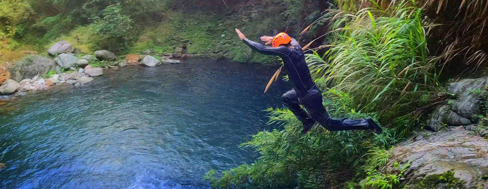
Lamin, from Funventures Taiwan, doing what he does best


Some sections are narrow...

...some sections are shallow...

...there's even this bat cave to explore!

The whole trace was incredibly beautiful. It seemed like we never came around a corner without at least one person saying, "Wow!" or, "Look at this!" or, "This is amazing!"


Andy pushes ahead


Once you get to this small waterfall, you know you are getting close to the end of the trace. Don't be fooled though - this is NOT the final waterfall! Climb up to the right of it, but make sure to check the depth so you can safely jump down before you do!


After the first waterfall, you will come to a long, narrow, and amazingly beautiful canyon section. It is full of deep water and the current is pretty strong, so it's important to have the strongest swimmers go first. Once they are past, they will need to put out a rope for anyone who is not as capable in the water.

Climbing up the waterfall at the end can also be challenging for anyone without good climbing skills.


The small waterfall is the final obstacle. Once you're past, it's just a few minutes to the end of the trace! Here is the last waterfall you will see, and it's a surprisingly beautiful one for how short it is compared to other waterfalls in Taiwan!

Surrounded by otherworldly, natural stone walls, this canyon waterfall is truly an amazing thing to see. What's more, it's really rewarding even for experienced tracers, and yet accessible for those with much less experience.


BUT... it's only the end of the trace for Map Room Explorers if we SAY it's the end of the trace! First, Andy took a turn in the lead and climbed all the way up the rock face on the right hand side of the waterfall. Unfortunately, it was a steep drop on the other side as well, and he wasn't able to see very far due to the angle of the canyon beyond, so...

...Lamin decided to help out with some drone scouting! If you've ever wondered what's further upstream from the waterfall, well, wonder no more! The picture below is what we saw:

There is one more beautiful, colorful section of canyon with one last, short waterfall at the end. Lamin flew a long way beyond this, but the canyon became less and less interesting. Of course it's possible there are hidden wonders yet to be found much further beyond, but if so, they are many miles away.
Once our curiosity and wanderlust were finally satisfied, it was finally time for us to go back. It had been an amazing, fun trace, and we left with great pictures, great videos and, of course, great memories!
THE NITTY-GRITTY
IMPORTANT NOTE:
All recommendations, times, and other information are for average conditions with average water levels. Please also see important safety notes for river tracing (below).
Length of trace:
Nan'ao Historic Trail: 3.5 km (one way) x2 = 7 km
Heliu Canyon: 2.7 km (one way) x2 = 5.4 km
Total: Roughly 6.2 km (one way) x2 = 12.4 km round trip
Time:
We took about seven hours in total, which was:
Nan'ao Historic Trail
1 hour in
1 hour out
Heliu Canyon
3:15 in at a relaxed pace, sliding, swimming, and taking pictures
1:45 out
...so if you planned a whole day for this, it would probably be a good idea.
Water sources:
It's one big water source the whole way, though with the increased number of visitors in the last few years you might want to consider bringing your own in a bottle. At a minimum, you will want a good water filter. If you decide to drink the water on the trace, it's better to take from a side stream, given how popular this trace has become.
Food:
We recommend bringing a lunch and drink for this trace.
Gear and provisions:
River tracing-appropriate shoes and clothes (see remarks), helmets, waterproof backpack, life jackets for anyone who is not a strong swimmer, water filter or other treatment options (see below), a waterproof headlamp or flashlight, a lighter (always!). A rope will also be very useful, or even essential.
Sun protection:
Useful, though there is good shade along much of the hike and trace. I found sunglasses, and sometimes a hat, useful on parts of this trace.
Yes, as far as the end of the Historic Trail. Beyond that, families who regularly do outdoor activities like hiking and river tracing together should be able to at least do part of the trace, and may easily be able to complete most or even all of it. Helmets, good swimming skills, and possibly life jackets, are highly recommended, so use your best judgement.
Dog friendly:
Nan'ao Historic Trail: Yes.
Heliu Canyon: No.
GPX file 1 of 2: Nan'ao Historic Trail / Heliu Canyon Trailhead 南澳古道/合流谷登山口
GPX file 2 of 2: Heliu Canyon, Yilan, Taiwan - The Map Room 台灣宜蘭合流谷 - 地圖寶庫


Check out the Map Room Members' Area for more maps, GPX links, and other members only perks!
Remarks:
Safety:
There are a few places along the Nan'ao Historic Trail where you might want to slow down just in case, but overall it is not too dangerous, as far as hiking in Taiwan goes. The first part of Heliu Canyon is fine for beginners, presuming you take the normal safety precautions (below); the second part is ok for intermediates. Just use your best judgement.
Parking:
Free, convenient parking is available right at the trailhead.
Water:
You will definitely need water for the hiking portion of this route! If you bring a filter, there are water sources along the Nan'ao Historic Trail, and you should be able to filter water from the Heliu River once you begin tracing. It's best to try getting water from side streams, though, as this is a popular trace and you are very likely to be downstream of other tracers much of the time.
River tracing gear and provisions (for basic not requiring rappelling and rock climbing skills and gear):
Clothes: Should be ok for swimming and getting dirty/torn, protect from scrapes. Quick drying, non-cotton, close fitting. UV reflective for hot traces, wetsuit for colder traces.
Boots: Neoprene or other river tracing specific boots (not shoes, NOT rubber or fishing boots!) to prevent blisters. High tops to keep stones out, soles to provide good grip and prevent slipping. I prefer felt soles for extra padding, especially after prior injuries. Some prefer alternatives which prevent organisms from being transferred between various streams and rivers.
Helmet: Designed for rock climbing.
Backpack: Waterproof. IPX 8 rating (protected when immersed in water over 1 meter / 3 feet) recommended.
Rope: Non-climbing rated, floating rope (that does not absorb water and get heavy) with knots is helpful, but NOT for doing serious climbs. Use ONLY for pulling weaker swimmers through more challenging stretches of water, and perhaps helping with scrambles up short sections of difficult terrain. For advanced climbing or rappelling, get advanced climbing rope, gear, and training!
Life jacket: If you are not a strong and confident swimmer.
Phone case: IPX 8 rating (protected when immersed in water over 1 meter / 3 feet) recommended.
Water filter or other water treatment options.
Waterproof headlamp or flashlight. IPX 8 rating (protected when immersed in water over 1 meter / 3 feet) recommended.

The Map Room recommends Fenix headlamps for high-quality, durable headlamps for hiking and river tracing (Amazon affiliate link*).
Lighter (always!)
Optional gear: A bandanna, headband, or other light cloth for wiping sweat is also often useful when you are not fully immersed in water.
Drinking water:
Choose water from a fast moving, clean source. This kills certain parasites, like giardia. Check upstream for polluting factors (dead animals, droppings, etc). Look for signs of pollution (vehicle tracks, lots of footprints). It's best to filter, and possibly either boil or otherwise treat it as well.

The Map Room personally uses and highly recommends the Sawyer Squeeze water filter (NOT the Sawyer Squeeze Mini - Amazon affiliate link*)
Important river tracing safety notes:
Strength and water levels of rivers change with rain, seasons, and other factors.
ALWAYS check the weather in advance of a river trace. If there is rain upstream, it is not advisable to go, due to the risk of flash floods.
If it has rained recently, rockslides are more likely. If the sun then comes out and evaporates recent rain, they are more likely still. Wear a helmet, and be sensible!
Stopping to rest in rockfall areas, under rock overhangs, or near sheer cliffs is not advisable due to the risk of rockfalls. Look for a wider, open area with less steep rock walls.
So now you're ready to go! Get out there, enjoy nature, be active, and have an amazing time!
Loved this article? Make sure to check out TMR's growing collection of river tracing articles!
Got questions or comments? Can you think of something we missed? Join in the discussion and leave a comment below. At the end of the day, we're just outdoors enthusiasts like you, and we'd love to hear from you!
All information on this page is intended for reference only. Preparing adequate food, water, and gear for your adventure, as well as following local rules and laws are, of course, your own responsibility! Always make sure that you check the weather for outdoor destinations, be careful and sensible for enclosed spaces like tunnels and bunkers, and bring a lighter - you never know when it could save your life! Now... get out there and have an amazing time!

10% discount on Parkbus Taiwan! Click the link and enter the discount code MapRoom10 for a 10% discount on Parkbus Taiwan rides!
The Map Room has an affiliate arrangement with Parkbus Taiwan and will receive a commission if you do. We stand strongly by our affiliates, because at the end of the day, they help get us safely to the end of the day.

Click the link above to get 20% off a year-long, premium Gaia GPS tracking and route planning subscription! The Map Room has an affiliate arrangement with Gaia and will receive a commission if you do... but we ONLY recommend products that we have tested, used, and loved in the field ourselves! We stand strongly by our affiliates, because at the end of the day, they help get us safely to the end of the day.

Hi! You love the outdoors and so do we! Please help support The Map Room so we can keep helping you do what we love to do!
*Please note that The Map Room participates in the Amazon Associate Program, and other affiliate programs. Some of the links on The Map Room may refer to Amazon or our other affiliates, and as a member of these, The Map Room will receive a commission at no additional cost to you. We ONLY endorse products we ourselves use, have used, or would use personally!


Comments