.png)
Jinyue Waterfall (金岳瀑布): Thunder and Wonder in Nan'Ao
- The Cartographer
- Oct 5, 2023
- 15 min read
Updated: Apr 27, 2024


INDEX
The Entrance Area / The Front Waterfall: Swimming, Jumping, and Sliding! / The Big Jump! / Between the Waterfalls / Jinyue Waterfall / The Emergency Exit (Alternative Access Route) / The nitty-gritty (GPS, GPX, and more)
"Here we are in October, and another typhoon is on the way. Who knows what will happen next? The Jinyue Waterfall jump spots are always filling in and getting cleared out."
Introducing this week's adventure:
Jinyue Waterfall (金岳瀑布): Thunder and Wonder in Nan'Ao
High cliff jumps, water slides, azure pools, and a 40 meter waterfall. Nanao's Jinyue Waterfall is a half-day trace that's hard not to love!
*Please note that The Map Room participates in the Amazon Associate Program, and other affiliate programs, and may earn from qualifying purchases at no extra cost to you.
The Entrance Area
Jinyue Waterfall! It's one of the most popular, and worthwhile, river traces in northeastern Taiwan - for many, many good reasons! With low, medium, and high cliff jumps, multiple water slides, azure pools, and an incredible 40 meter waterfall all in easy access, it's a prime destination for serious river tracers, families with small children, and anyone in between.

Taiwan, of course, is full of amazing river tracing destinations, but not many offer such a perfect combination of activities for so many different skill levels as the Jinyue Waterfall river tracing route. Don't let that fool you, though - this is definitely a destination worth the time for more advanced and adventurous tracers!

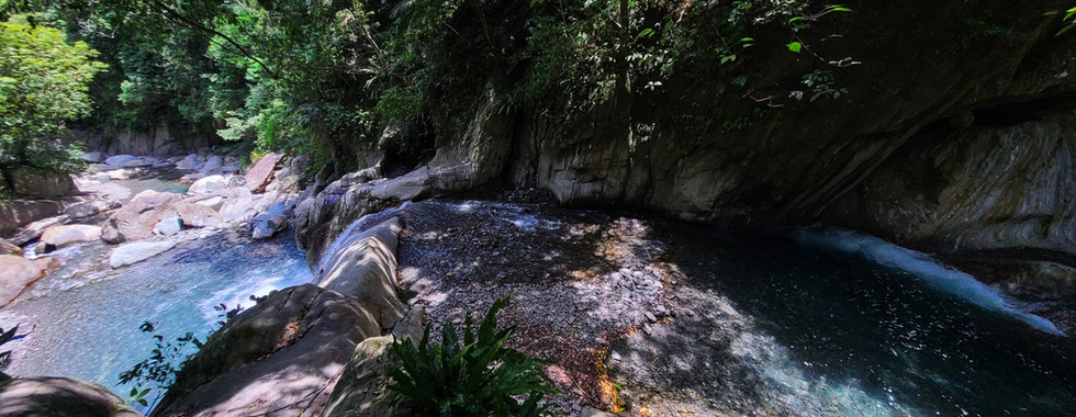
Jinyue Waterfall (金岳瀑布) is located in Yilan's Nanao (台灣,宜蘭,南澳). It is actually two waterfalls, a whole collection of cliff jumps, and several perfect swimming pools, all jam-packed together on the same short stretch of the Lupi River (鹿皮溪).

The river trace is not far from Nanao, in Yilan, and parking is easy and convenient. If you are driving a car, there are several well-maintained parking lots right at the trailhead for only a small fee. If you're on a scooter, though, you're really in luck! Just pass through this yellow barricade (above) to the free parking (below) and you're there!


Once you walk past the scooter parking you will see these stairs.

As soon as you reach the bottom, you will find a nice, sunny swimming area. Locals often bring toddlers and small children here, have barbecues, and so on. Turn left and head upstream for just a few minutes you will get to the first waterfall.

The Front Waterfall: Swimming, Jumping, and Sliding!

Now, first of all, we have to get one thing straight: The name, 'Jinyue Waterfall' is a bit misleading. There are actually two waterfalls on this trace - the front one (smaller, above and below) and the back one (much, MUCH taller - link). The name, 'Jinyue Waterfall' is often used interchangeably for one, the other, or even both, and other names, like Lupi River Big Waterfall (鹿皮溪大瀑布), for the taller, back waterfall) are also floating around out there.

For the purposes of this blog post, I will be referring to the smaller one (above, below) as the Jinyue Front Waterfall (or just the front waterfall), and the back one as the Jinyue Back Waterfall (or the big waterfall).

The front waterfall and swimming pool are tons of fun! You can jump off the waterfall, and it is also a natural water slide. Every time I go there, I end up going over the waterfall at least 10 times!

Of course, you should always check the depth of any jump or slide before going over it for the first time on any given day no matter how many times you've been there before. You never know when something may have washed in - just wait until you see below for a mind-blowing example of that! Waterflow is also very important. Just take a look at these two pictures compared to the ones above. This is what the water flow was like a week or so after a typhoon.

I love sliding down this waterfall (VIDEO), and I do it multiple times each time I visit. For strong swimmers, and those with life jackets, it is generally safe in normal water levels. However, I once personally saw a girl who was unable to swim slide down without a life jacket. Even though conditions were normal, she almost ended up drowning, and I had to pull her out to save her from drowning.

Stories like this are why, despite all the fun, it's important to remember that there have been accidents on this trace, and people have gotten lost, stuck, and even drowned. However, this has usually been because, like the girl above, people did not respect the conditions, did not plan adequately in light of the weather forecast, or made poor decisions, rather than because this trace is particularly dangerous overall.

On another occasion, a whole river tracing tour group needed to be rescued because they went in during high water flow, got caught in rain, and were unable to exit from the back waterfall area. In fact, there is a little-known emergency exit with multiple exits along the trace, so even if you are unfortunate enough to get stuck in the wrong conditions, you should be able to get out without any problems if you know about it.

Despite all of that, this really is a good trace for beginner and intermediate level tracers, and even advanced tracers will have a lot of fun despite how short it is. I know I have been there many times over the years, and I still haven't gotten tired of it!

There are actually not one but two amazing, azure swimming pools at the front waterfall. There is the one below it, and this one (pictured above) just above it. This pool is also a really great example of how much typhoons can change a river in a short time. When I first came here all the way back in 2012 or 2013, not only was this pool deep enough to jump in, but there was a tree to climb up high overtop of it. Ten years later, in summer of 2023, I returned to find that it was almost completely filled in with gravel. Then, in September of 2023, it was back to being deep - though not as deep as 10 years before, with no more tree, and it will keep changing regularly!
Here are two videos of the jump from 2013 - one below, and another that, unfortunately, I can only link to for now because it is in portrait format. It was a great jump, and may come back some day, so take a look at the video!

To get up to the top of the front waterfall, you can either climb up on the left side (faster, but more challenging), or walk up the trail to the right (easier, slightly longer). Just go up where I'm pointing in the picture above!
The Big Jump!
Once you've finished having fun at the front waterfall area, follow the trail for a few minutes up into the forest. You should come to this narrow canyon section in no time. I've had tons of fun doing some of the best jumps in the whole of Nanao here, off this cliff!

Now, if you've been paying attention, you should have noticed that this picture shows the canyon full of rocks. In fact, I took this during summer of 2023, at the same time when the swimming pool above was almost completely filled in. As you can see, it's literally only ankle deep, and it was DEFINITELY not a good idea to jump at that time!

I was disappointed when I heard, and then saw, that the jump spot had been filled in by a typhoon. But, I had seen this before: It wasn't long until another storm came in, cleaned it out, and changed it back to jumpable condition literally overnight! Typhoons can move hundreds, and even thousands, of tons or rocks in a very short amount of time, to say nothing of trees and other debris. That's why you ALWAYS need to check the depth before jumping for the first time on a given day, no matter how many times you've jumped the spot over the years!

Fortunately, as of September of 2023, the canyon section was jumpable again. It offers jumps of different heights, including one I estimate to be over 12 meters high - the highest I have found in the area. Here is another vertical video of the jump, and a bunch of water slides, all the way down to the first waterfall! Then again, here we are in October, and another typhoon is on the way. Who knows what will happen next? The Jinyue Waterfall jump spots are always filling in and getting cleared out.
Between the Waterfalls

Up until the jumping cliff, the entire trace is still suitable for beginners. From there on, while not difficult compared to some other traces, it's best to have at least intermediate level experience and capabilities, or come with someone who is more capable.

The jungle road quickly brings you back to the river just beyond the canyon, and from here on you can either do an intermediate level trace through the beautiful river, or take the very well hidden entrance to the emergency exit, which will let you pass some, or even all, of the trace and get to the Jinyue Big Waterfall / Lupi River Big Wterfall (鹿皮溪大瀑布) much more quickly.


Here are some pictures of the trace in high water conditions. Most times, it's a great trace, but even I was unable to pass some of them with that amount of water flow, so I was really glad to have a way around!


At some points, you can trace right up the river. At other points, you have the option to follow cliffs around more challenging sections if you want.


Jinyue Waterfall

The first view of the back waterfall at Jinyue is guaranteed to amaze. You come around a corner, and suddenly you see it: an incredibly tall waterfall pouring down tens of meters from far above into the river canyon ahead. During normal waterflow, it's a sight to behold. During high waterflow, it's a raging beast, and an absolute force of nature!

You hear the big Jinyue Back Waterfal (or Lupi River Waterfall as it's sometimes called) long before you see it. The closer you get, the louder it becomes.

This is a truly magnificent, and powerful, waterfall! Sometimes the pool is small (like in these pictures); other times, it takes up nearly the entire open area around its base. But no matter what, it is literally earth-shattering, and it always makes an impression!


Here it is during high water flow. It's amazing the difference! Standing there at most times it's already beautiful. But when the water pours out with this much power, it's like standing in the presence of some elemental spirit, thundering and blustering and billowing out enough cold steam to fill the entire area!

Trying to stand up straight in front of the waterfall is like trying to face down the winds of a typhoon. It doesn't matter how strong you are, you have to work at it or it is definitely going to push you over like a bug in the wind!

Other times, the waterfall is calm, elegant, and graceful.

It's such a contrast, and such a lesson in just how truly alive and changing rivers, waterfalls, and all of nature really are!

The Emergency Exit / Alternative Access Route
Now of course, with so much difference between the waterflow depending on conditions, the experience of tracing any river can be vastly different from one visit to the next. With Jinyue's waterfalls being located in a pretty narrow canyon for much of the way, this can be even more of an issue!

As mentioned above, even larger guided tour groups have been known to get stuck and need rescue here in the wrong conditions. Fortunately, on one of my recent visits, I discovered that there is a well developed walking trail running the length of the river as far as the back waterfall. It even has stairs, observation platforms, seating areas, and a direct exit to a road above!

To access the Jinyue Walking Trail, cross the river as soon as you exit the very obvious trail above the canyon section. The entrance is a bit hidden, so you may have to look around, but it is there - stairs and all - behind some obscuring boulders.

Once you have found the entrance, the trial itself is incredibly obvious. You can enter and exit from multiple points along the river, allowing you to take it all the way to the back waterfall, simply avoid a few obstacles, or anything in between.


At one point early on the trail forks. If you go down to the right, it takes you to the river. Up to the left will go past some rest areas to an observation platform with a great view of the waterfall. There is even a way to go up and down directly between the platform and the waterfall itself!


If you choose to go up at the fork, you will end up at an observation platform with a great view of the waterfall. From this point, the trail continues up the hill for a long way. There is one more fork further up where you want to go left if you need to get to the road. Going right will take you to the middle of the jungle, where there is a small rivulet, and is not really worth the time unless you want a casual hike (see map and GPX for details on all of this).

There is also a smaller trail hidden on the far side of the observation platform. While clearly not part of the official walking trail, and a little steep, it's not really all that bad. it will take you directly down to Jinyue Waterfall itself in a matter of minutes.

The little trail could be handy for skipping parts of the trace to get to Jinyue faster, coming down for a quick swim from the road above (though this really doesn't make much sense as a plan most of the time, in my personal opinion) or, importantly, as an emergency exit to exit the river area. Again, details are in the maps and GPX of this blog post.

If you want to go up for the bonus view at the platform after tracing to the waterfall, though, well, that makes more sense to me. I know I'll be doing this from now on whenever I go! At the time of writing, there was a small rock pile serving as a sort of stairway to get up to the entrance to the trail. Just look at the two pictures above to see where it is (or should be).


Getting up to the road is a long hike, and it will leave you breathing hard. For a casual visit, or even for a trace, I really don't recommend going any further than the viewing platform at the most, and maybe even skipping that. But it's always good to know where the emergency exits are, just in case!

So that's it - the front and back Jinyue Waterfalls on the Lupi River in Nanao! With all the jumps, slides, swimming holes, and amazing, beautiful, and colorful scenery, it's easy to see why this popular river tracing destination is one of the best in northern Taiwan. It's one of the first places I ever went river tracing, and over a decade later, I'm still coming back for more!

So what are you waiting for? Get out there, check out Jinyue, and go have some fun!
THE NITTY-GRITTY
IMPORTANT NOTE:
All recommendations, times, and other information are for average conditions with average water levels, and are for reference purposes ONLY. Please also see important safety notes for river tracing (below).
Length of trace:
Roughly 1.3 km one way (2.6 km round trip)
Time:
MY TIME: 2:10, but I was fast and moving fast. Plan a half a day at least, just so you can enjoy yourself!
Water sources:
You can filter the water from the river, but it is surrounded by farms and roads. It may be better just to bring your own.
Food:
Bring snacks (if you are fast) or a lunch (if you are not) to enjoy on this trace. DO NOT eat in the big waterfall area itself - it is prone to rockfall!
Gear and provisions:
River tracing-appropriate shoes and clothes (see remarks), helmets, waterproof backpack, life jackets for anyone who is not a strong swimmer, water or water filter, a waterproof headlamp or flashlight, a lighter (always!).
Sun protection:
Useful if you're tracing, though the hiking trail is through a shaded forest. Also useful when you are in the waterfall areas themselves.
Front waterfall:
Yes! Bring your babies and toddlers - the locals do all the time!
Back waterfall:
Probably for children 8 and older, with outdoor experience, in reasonably good shape, with proper safety equipment and experienced adult supervision. Good swimming skills, and possibly life jackets, are recommended. Use careful judgement, and remember you have the hiking trail as an alternative / emergency exit route.
Dog friendly:
Front waterfall:
Yes! Bring Fido - but take his droppings out when you leave.
Back waterfall:
Probably, for larger dogs with outdoor experience, especially if you take the hiking trail into consideration. Still, use careful judgement whenever bringing pets into the great outdoors.
GPX file 1 of 2: Jinyue Waterfall (Lupi River) - The Map Room 金岳瀑布(鹿皮溪) - 地圖寶庫
GPX file 2 of 2: Jinyue Waterfall Emergency Exit Hiking Access Route - The Map Room 金岳瀑布經濟出口爬山路線 - 地圖寶庫.gpx

GOOGLE MAPS LINK:
Trailhead: 24.46831, 121.75319

Check out the Map Room Members' Area for more maps, GPX links, and other members only perks!
Remarks:
Safety:
This is a popular destination with locals and people from outside the area. As river traces go, it is pretty beginner level, and pretty safe. However, I DID have to save someone from drowning at the front waterfall once (she was unable to swim and foolishly slid down the waterfall into the deep pool...), so be mindful of your swimming skills.
Parking:
Cars:
There is plentiful pay parking readily available.
Scooters:
You can park for free in the area near the top of the steps.
Water:
Bring a filter or bring it with you.
River tracing gear and provisions (for basic not requiring rappelling and rock climbing skills and gear):
Clothes: Should be ok for swimming and getting dirty/torn, protect from scrapes. Quick drying, non-cotton, close fitting. UV reflective for hot traces, wetsuit for colder traces.
Boots: Neoprene or other river tracing specific boots (not shoes, NOT rubber or fishing boots!) to prevent blisters. High tops to keep stones out, soles to provide good grip and prevent slipping. I prefer felt soles for extra padding, especially after prior injuries. Some prefer alternatives which prevent organisms from being transferred between various streams and rivers.
Helmet: Designed for rock climbing.
Backpack: Waterproof. IPX 8 rating (protected when immersed in water over 1 meter / 3 feet) recommended.
Rope: Non-climbing rated, floating rope (that does not absorb water and get heavy) with knots is helpful, but NOT for doing serious climbs. Use ONLY for pulling weaker swimmers through more challenging stretches of water, and perhaps helping with scrambles up short sections of difficult terrain. For advanced climbing or rappelling, get advanced climbing rope, gear, and training!
Life jacket: If you are not a strong and confident swimmer.
Phone case: IPX 8 rating (protected when immersed in water over 1 meter / 3 feet) recommended.
Water filter or other water treatment options.
Waterproof headlamp or flashlight. IPX 8 rating (protected when immersed in water over 1 meter / 3 feet) recommended.

The Map Room recommends Fenix headlamps for high-quality, durable headlamps for hiking and river tracing (Amazon affiliate link*).
Lighter (always!)
Optional gear: A bandanna, headband, or other light cloth for wiping sweat is also often useful when you are not fully immersed in water.
Drinking water:
When sourcing water in the wild, choose water from a fast moving, clean source. This kills certain parasites, like giardia. Check upstream for polluting factors (dead animals, droppings, etc). Look for signs of pollution (vehicle tracks, lots of footprints). It's best to filter, and possibly either boil or otherwise treat it as well.

The Map Room personally uses and highly recommends the Sawyer Squeeze water filter (NOT the Sawyer Squeeze Mini - Amazon affiliate link*)
Important river tracing safety notes:
Strength and water levels of rivers change with rain, seasons, and other factors.
ALWAYS check the weather in advance of a river trace. If there is rain upstream, it is not advisable to go, due to the risk of flash floods.
If it has rained recently, rockslides are more likely. If the sun then comes out and evaporates recent rain, they are more likely still. Wear a helmet, and be sensible!
Stopping to rest in rockfall areas, under rock overhangs, or near sheer cliffs is not advisable due to the risk of rockfalls. Look for a wider, open area with less steep rock walls.
So now you're ready to go! Get out there, enjoy nature, be active, and have an amazing time!
Loved this article? Make sure to check out TMR's growing collection of river tracing articles!
Got questions or comments? Can you think of something we missed? Join in the discussion and leave a comment below. At the end of the day, we're just outdoors enthusiasts like you, and we'd love to hear from you!
All information on this page is intended for reference only. Preparing adequate food, water, and gear for your adventure, as well as following local rules and laws are, of course, your own responsibility! Always make sure that you check the weather for outdoor destinations, be careful and sensible for enclosed spaces like tunnels and bunkers, and bring a lighter - you never know when it could save your life! Now... get out there and have an amazing time!

Click the link above to get 20% off a year-long, premium Gaia GPS tracking and route planning subscription! The Map Room has an affiliate arrangement with Gaia and will receive a commission if you do... but we ONLY recommend products that we have tested, used, and loved in the field ourselves! We stand strongly by our affiliates, because at the end of the day, they help get us safely to the end of the day.

Hi! You love the outdoors and so do we! Please help support The Map Room so we can keep helping you do what we love to do!
*Please note that The Map Room participates in the Amazon Associate Program, and other affiliate programs. Some of the links on The Map Room may refer to Amazon or our other affiliates, and as a member of these, The Map Room will receive a commission at no additional cost to you. We ONLY endorse products we ourselves use, have used, or would use personally!