.png)
Xiaojinping: 5 Hot Springs, 3 Waterfalls, 2 Mountains, 1 Hot Destination! (January 2023 update)
- The Cartographer

- Feb 23, 2022
- 18 min read
Updated: Apr 27, 2024


Index
The Hot Springs Area / The Waterfalls and River Tracing / Jinping Creek Waterfall (錦屏溪瀑布) / Xiaojinping Waterfall (小錦屏瀑布) / Little Rock Waterfall and Water Slide (小岩瀑布和自然滑水道) / Hiking: Jinping Mountain, Gaotai Mountain, and Beyond / The Nitty-Gritty (GPS, GPX, map, and more)
Xiaojinping Hot Spring Area Map
Taiwan Hot Springs Master Map
IMPORTANT UPDATE:
January 14, 2023
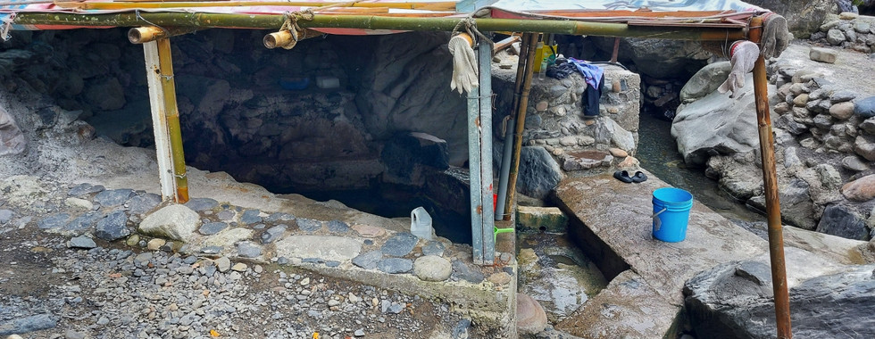
The first Xiaojinping pool suffered a catastrophic collapse in a landslide, and there was one fatality. As of January 2023,the other hot springs are all intact. Here is a gallery of the current situation.


*Please note that The Map Room participates in the Amazon Associate Program, and other affiliate programs, and may earn from qualifying purchases at no extra cost to you.
Introducing this week's adventure:
Xiaojinping: 5 Hot Springs, 3 Waterfalls, 2 Mountains, 1 Hot Destination! 小錦屏:五個溫泉,三個瀑布,兩座山,一個超棒的地點!
With five hot springs, three waterfalls, one easy hike and an advanced hike, the Jinping River (錦屏溪) area in Hsinchu's Jianshi County in Taiwan (台灣新竹尖石) is both a relaxing, family friendly, river tracing and camping destination and a challenge for more advanced adventurers. In a word, this place truly has something for everyone!
The Hot Spring Area
Jinping Creek and the surrounding are are a great outdoors destination in Hsinchu County's Jianshi, Northern Taiwan. With extremely easy access to at least five hot springs at the time of writing, trails to two mountains, lots of waterfalls, and good river tracing options, there's definitely something for everyone here!

There is a road leading directly to the hot spring, though some sections are steep and rough. However, recent renovations mean that the worst - and previously almost completely impassible - parts of the road have been re-paved and replaced. Be prepared for some seriously steep uphill and downhill sections on the way, though!

Look closely and you can see one of the waterfalls from this hilltop on the road!

Parking/camp area along the road. You can see Jinping Creek Waterfall (錦屏溪瀑布, below) when standing here.
There are a number of easily accessible camping areas. The only real challenge here is to make sure that you can find a space - the ease access means that just about everyone wants to come out here on any weekend or holiday.

Finding a place to camp can be a challenge, as the area is easily accessible and very popular

Asher soaks in the oldest hot spring
THIS HOT SPRING WAS DESTROYED IN LATE 2022, but the others are intact. We will update this if it is restored.

The oldest hot spring
THIS HOT SPRING WAS DESTROYED IN LATE 2022, but the others are intact. We will update this if it is restored.
Though this is a free, wild hot spring, it needs to be dug out regularly after large storms. The local community is very active in maintaining and expanding it, and you are likely to see old men, in their 60's or older, digging, moving rocks, and pouring cement. This does, of course, mean that you won't see even a little bit of the beautiful greens, whites, and other colors of some hot springs, so if that, or privacy, are what you're after, it's probably best to go elsewhere.

This is the smallest 'hot spring.' It's actually a bath tub with a bit of natural hot water flowing slowly into it. Don't count on being able to use it though - this old gentleman basically lives there, and I've never seen it without him in the tub!


This newer hot spring, though shallow, is still a good temperature and well covered. The rooves serve two purposes: Blocking the small rocks that frequently fall down from the cliffside above, and keeping rain out during bad weather.


This new addition is the largest of the bunch. It may not be beautiful, but when we last visited it definitely did a great job of keeping the icy rain off! We also had a chance to chat with the locals.


There's even a little changing area off to the side.
Now, of course, this is not the ideal kind of hot spring for every visitor. If you are one who prefers unspoiled nature, seclusion, or just less cement and more dirt and stone, you may be disappointed. If you're looking for a good, easily accessible, wild, and free hot spring, though - perhaps to bring a small child, or even toddlers or babies to - this may be a destination for you!
The waterfalls and river tracing
The hot spring area is only the beginning of the adventure though! There are several rivers to trace and a number of mountains to hike as well. Just trace upstream towards the suspension bridge (below) and within minutes you will come to a fork where two rivers come together.
Jinping Creek Waterfall (錦屏溪瀑布)


Head under the suspension bridge and stay on the main river first. This will bring you Jinping Creek Waterfall (錦屏溪瀑布). It's beautiful, easily accessible, and rewarding, and best of all, it has a big, beautiful, azure swimming pool right at the base!

Jinping Creek Waterfall (錦屏溪瀑布)

It's possible to trace further upstream from here, but getting past the waterfall is difficult and a bit technical. To do so, you have to backtrack, find your way onto the road, walk up, and look for a good place to climb down through the jungle once you've passed the waterfall. Instead of doing this, it's best to head back downstream to the river fork at the bridge and either follow the other river upstream or cross the bridge and follow the path a while.

Heading upstream from Jinping Creek Waterfall is a good adventure for the more experienced explorer


Xiaojinping Waterfall (小錦屏瀑布)

Heading up the other branch of the river, you will pass a few interesting places, the first of which is Xiaojinping Waterfall (小錦屏瀑布). Keep your eyes open and you can even find fool's gold (pyrite)! Interestingly, this waterfall has an alternate name, 黃金洞瀑布 (Golden Cave Waterfall), which may be derived from them.

Deposits of fools gold (pyrite) near the

Xiaojinping Waterfall 小錦屏瀑布
After a few more minutes, you will come to a second, even bigger waterfall! This is Xiaojinping Waterfall (小錦屏瀑布). Like Jinping Creek Waterfall, it is quickly and easily accessible, big, beautiful, and has a gorgeous azure swimming pool underneath. Also like Jinping Creek Waterfall, it is completely impassible from this point - though getting past it is not at all difficult. Once you've had your fill of swimming, look for the small path that heads up to the main, well marked trail (see below). From here you can either reconnect with the river and trace upstream or follow the path, continuing all the way to the third and final easily accessible waterfall in the area.
Little Rock Waterfall and Water Slide (小岩瀑布和自然滑水道)

Next up is Little Rock Waterfall and Water Slide (小岩瀑布和自然滑水道). This one is a special treat because it's a double waterfall, AND because there is a natural water slide there! It's also beautifully colored.

There are some VERY old ropes going up to the sliding area. At the time of writing, they hadn't broken yet... but be careful! Don't worry if you slip though, just stay calm and let yourself slide down the smooth rock face. Sure it's most fun sliding down the waterfall itself, but almost anywhere along here is safe to slide down, as long as you're careful and just keep your wits. Personally, I love to slide down the wet, slimy, dark section to the right of the waterfall!

Some people come with professional gear. This is a good option, but not the only way up


Relaxing on top of the first of two waterfalls at Little Rock Waterfall and natural waterslide (小岩瀑布和自然滑水道) before sliding down

Once you're at the top of the first waterfall, there are still more ropes ahead. If you're careful, strong, experienced, and confident in your abilities, then you can try to get on through to the second one. This is NOT recommended for the inexperienced, though!

The second tier of Little Rock Waterfall (小岩瀑布)
The second tier is more difficult to reach, and much harder to get past. For many visitors, the first tier is the best stopping point, and the second one should be the end of this trace for most of the rest. Tracers with advanced experience, good skills, and good judgement can attempt to go further upstream, but it is tricky and can be very dangerous getting past.
Climbing around the second waterfall. These ropes are old and you have to be careful!

The view from the top of the second tier at Little Rock Waterfall (小岩瀑布)
Hiking: Jinping Mountain, Gaotai Mountain, and Beyond
If tracing isn't your thing, or if you've had enough water for one day, there are also two different trails to two separate mountains both starting in this area. The first trailhead, the one for Gaotai Mountain and the three Daotian Peaks (高台山-小,中,大島田山縱走 - detailed blog post here!), is up on a side road near the top of the hill before the final descent to the hot spring area. The entrance is marked on the map in this post, and you can see the full map and details at the link above. This hike is by far the easier of the two options, and is suitable for high beginner and low intermediate hikers.

Click on this image to explore Gaotai Mountain and the three Daotian Peaks (高台山-小,中,大島田山縱走)

The second hike, Jinping Mountain (錦屏山), is much more difficult and demanding than Gaotai Mountain, and should not be attempted by the inexperienced. To reach the trailhead, cross the suspension bridge.

View downstream towards the hot spring from the suspension bridge

As soon as you reach the other side of the bridge you will find this sign marking a fork in the trail. If you continue straight, you will end up at Xiaojinping Waterfall (小錦屏瀑布) and Little Rock Waterfall (小岩瀑布, see above). To head towards Jinping Mountain, though, you need to turn left and head up the hill. You might as well get used to it - you'll be heading up a merciless, endless, very challenging, and quite rewarding uphill for many hours to come!
DEFINITELY be SURE to bring a headlamp, water, and food for this one - it's going to take you a long time to get up!

Looking back at the suspension bridge from the Jinping Mountain (錦屏山) trailhead

Just above the trailhead you will encounter this 獵人教室 (literally, "hunters' classroom").

The "hunters' classroom" (獵人教室 - above, below) is a quieter place.

The second hike, Jinping Mountain (錦屏山), is much more difficult and demanding than Gaotai Mountain, and should not be attempted by the inexperienced.

The trail soon splits again at this sign. You can follow it down to Xiaojinping Waterfall (小錦屏瀑布) or keep going straight towards Jinping Mountain (錦屏山) and Little Rock Waterfall (小岩瀑布). Confusingly, this sign calls it 黃金洞瀑布 (Golden Cave Waterfall), perhaps because of the fools' gold deposits nearby. Soon, it will split again, and this time you are finally heading up the mountain.

Heading up Jinping Mountain

The trail up to Jinping Mountain is serious business. While it is not as technically challenging as some others, it is a very, very long uphill stretch with almost no breaks on the way. This mountain is good training for anyone preparing to head up to the more serious, 3000+ meter mountains in Taiwan, and it definitely takes a lot of time and energy to get to the top! For this reason, it is best to set an absolute turn-around time and, if you hit it, really do turn around. Otherwise, you may very well find yourself hiking for quite a long time on technical terrain in the dark (again, be sure to bring a head lamp, water, and adequate provisions for a full day of hiking).

Old logging road segment on the way up Jinping Mountain


Steep uphill and climbing sections such as these are common on the Jinping Mountain trail
When I climbed Jinping Mountain, I found having real-time GPS tracking and topographical (topo) maps on my phone extremely useful (Article: How To Use Hiking Topographical Maps, Satellite Imagery, and Other Resources to Plan Hiking Routes). I used Gaia GPS (our affiliate, because we use it!) and it really made a difference to help me pace myself, know how far I had come, see how much further I still needed to go, and anticipate and prepare myself for sudden uphills and other features along the way. Other apps, like Alltrails and Hiking Biji, have similar functionality, though I find them to be more limited when hiking or tracing offline.

Beautiful view on the Jinping Mountain Trail

Once you are near the top, you will come across the abandoned foundations of an old structure in a wide, flat area about 20-30 minutes' hike below the peak. This can be a good campsite - though there is no water source - or a nice place to stop for a snack or lunch.

Bottles and other artifacts at the abandoned site
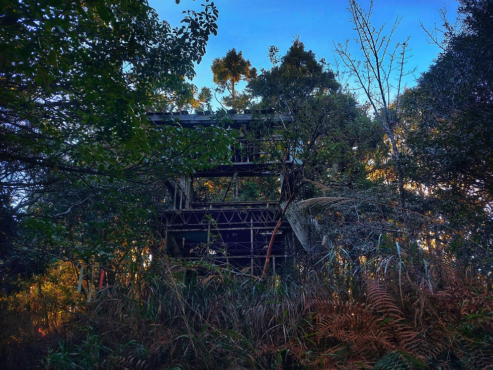
The abandoned building on top of Jinping Mountain
Once you finally reach the top, you will find this abandoned structure. It's really interesting, and you can set up a tent or two there. There is no water source, though, so if you intend to camp you will need to bring your own water up the mountain!

Sign at the peak of Jinping Mountain in Hsinchu, Taiwan (台灣新竹錦屏山)

Camping next to the abandoned structure on the peak of Jinping Mouintain (錦屏山)

Sunset on the Jinping Mountain Trail
Once you reach Jinping Mountain, it is possible to continue on in a loop and return to Xiaojinping Hot Spring. This is a serious hike, and not to be taken lightly, but for experienced hikers in very good physical condition who are prepared it is possible to set off from the suspension bridge area early in the morning, push hard all day, pass over Shimada Mountain (石麻達山), come around to the back side of the three Daotian Peaks (小,中,大島田山), continue on to Gaotai Mountain (高台山), and come back down to the trailhead mentioned above. Again, take this loop seriously - people have gotten lost and even died on this hike - but if you are experienced and prepared, it's a great loop, and highly recommended!
THE NITTY-GRITTY
GPX file 1 of 2: Xiaojinping to Jinping Mountain - The Map Room 小錦屏-金瓶山-地圖寶庫.gpx
GPX file 2 of 2: Xiaojinping 1 Hot Spring River Tracing - The Map Room 小錦屏溫泉溯溪-地圖寶庫.gpx
PLEASE NOTE:
There are two additional routes shown on the map. These were contributed by TMR's team, but have not yet been given the same detailed verification and refinement process that most of our mapped routes go through. They are displayed on the map for reference only, and not included here for download. We will add them at a future date, once we are able to revisit and revise them properly. For now, enjoy!

GOOGLE MAP LINK TO THE TRAILHEAD (XIAOJINPING HOT SPRING) GOOGLE MAP LINK TO THE TRAILHEAD (GAOTAI MOUNTAIN) GOOGLE MAP LINK TO THE TRAILHEAD (JINPING MOUNTAIN)

Check out the Map Room Members' Area for more maps, GPX links, and other members only perks!
Skill level:
Xiaojinping Hot Spring: Novice
Gaotai Mountain and the Daotian Peaks: Low intermediate
Jinping Mountain: Low advanced
Length of hike / trace:
Xiaojinping Hot Spring:
Minutes
Gaotai Mountain and the Daotian Peaks:
MY Time: Part 1: 52 minutes. Part 2: 2 hours, 9 minutes. Part 3: 45 minutes. MY total: about 3 hours, 45 minutes. IMPORTANT: I am very fast, and I was moving fast. I advise planning more like 5-6 hours total for this. Better yet, leave early in the morning, dedicate the day for it, and come back in the evening.
Jinping Mountain:
MY Time: Part 5:30 up, 4:10 down. MY total: 9:40. IMPORTANT: Though I was packing a full backpack with overnight gear, and recovering from a shoulder injury, I am still very fast, highly experienced, and made good time. I recommend leaving early in the morning, dedicating the day for it, taking a headlamp, setting a non-negotiable turn around time, and coming back in the evening regardless of whether or not you make the peak. This is a physically demanding ascent!
Water sources:
Hot spring area:
There is a small pipe running water into a plastic jug with a valve on the hillside next to the lower parking area. I recommend filtering this or bringing your own. With so many people regularly using, littering in, bathing in, and even using the bathroom in the river, I recommend against using the water in the area near the hot spring.
Tracing deeper:
Use a water filter or just bring your own.
Both mountains:
Bring your own or filter from the water source mentioned in the hot spring area part just above.
Gear and provisions:
Hot spring area:
River tracing shoes, a towel, and whatever you need to be comfortable in a relaxing, semi-natural hot spring setting. Don't forget snacks and water or a filter (see above).
The mountains:
Good hiking shoes, hiking-appropriate clothes (see remarks), enough water (see below), a lighter (always!), a headlamp or flashlight, lunch and snacks. Hiking poles recommended.
The tracing areas:
River tracing-appropriate shoes and clothes (see remarks), helmets optional, waterproof backpack recommended but not necessarily required, life jackets for anyone who is not a strong swimmer, water filter or other treatment options (see below), a waterproof headlamp or flashlight, a lighter (always!). I also always bring a rope wherever I trace.
Sun protection:
Hot spring area:
Possibly for wandering around outside the soaking areas, but the hot springs themselves are rooved and well-shaded.
The mountains:
Not generally necessary on these well-forested and shaded hikes.
The tracing areas:
Recommended.
Hot spring area:
Absolutely! I have seen many, many children and elderly people here. You can easily bring an infant - with all the normal baby-by-the-water caveats.
Gaotai Mountain:
Yes for children 12 or older. Out of shape adults will find both parts of this hike strenuous.
Jinping Mountain:
Yes for children 12 or older with mountain hiking experience (this will likely be strenuous for them). Adults in less than good physical condition will find this hike strenuous as well. Keep in mind that this is a serious, unrelenting uphill with few exceptions the whole way, and there are some somewhat technically challenging sections both up and down. It's worth it, though!
The tracing areas:
Yes for children 7+ up the left fork to Jinping Creek Waterfall (錦屏溪瀑布), up the right fork as far as Xiaojinping Waterfall (小錦屏瀑布), and downstream from the hot spring towards the entrance road. One of our Map Room Explorers, a father of four, has taken children as young as five on some parts of this. Additionally, it may be possible for them to walk along the jungle path as far as Xiaoyan (LIttle Rock) Waterfall (小岩瀑布). Passing beyond these points, the tracing gets more technical and demanding, so it's not recommended to take young children beyond them.
Dog friendly:
Hot spring area:
Yes, easily. Please keep them under control out of respect for your fellow bathers!
Gaotai Mountain and the Daotian Peaks:
Only for large dogs up to Gaotai, not for the Daotian Peaks
Jinping Mountain:
Under no circumstances!
The tracing areas:
There are some more easily accessible areas where you might be able to bring larger, outdoor-experienced dogs for a ways, but not when going into the deeper parts of the traces. I would generally recommend against it, but use your best judgement.
Camping /overnighting options:
Hot spring area:
There are many, many campsites now in the immediate vicinity of the hot spring, as well as alongside the last stretch of road before the parking area. These are popular, so you will likely not be alone! People also regularly car camp in the parking area.
Gaotai Mountain and the Daotian Peaks:
There is a wonderful - and very popular - campsite just behind Gaotai Mountain. It is one of my favorites in all of Taiwan... but it's also very popular and has no water source. Details at the Gaotai post.
Jinping Mountain:
There are a number of campsites generally suitable for 1-3 tents on the way up the mountain, as well as right on the mountain top (2 tents). There is also the Japanese ruins area just below the peak, which is wide and can fit many, many tents. Keep in mind that there are no water sources once you leave the river, though! See the map and GPX file for exact locations.
The tracing areas:
You can probably find some wild campsites, but I usually just do it as a day trace and base out of the hot spring area.
Remarks:
Parking:
Aplenty! Just be sure that you consider carefully before going down the final part of the road, since it's very steep and may be difficult coming back up for some vehicles. If you are unsure, you can just park a bit up the hill at any of several obvious spots and walk the rest of the way down pretty quickly.
Water:
Hot spring area:
Whatever you'd bring / filter to spend time in a hot spring resort.
Gaotai Mountain and the Daotian Peaks:
For this hike, I personally might drink 1.5-2 liters per day in winter, 2+ in summer, but I drink a lot of water and you may drink less than me. It's better to have extra than too little, though!
Jinping Mountain:
I needed all 3 liters up and back, and it was not winter. However, I was packing a fully loaded overnight pack, and I drink a lot of water compared with some people!
The tracing areas:
My approach would be to either just bring a filter (see above, below) or bring a small bottle of water I could filter and refill.
Notes for hiking:
Clothes:
Regardless of the hike, it ALWAYS pays off to have appropriate hiking clothes! These should be clothes you don't mind getting dirty and/or messed up. Pants, shirts, socks, and underwear should all be quick wicking to get sweat off of your skin and quick drying to get it off of your clothes. For these reasons, you should NEVER wear cotton hiking! Sports pants and a sports shirt are a good place to start, but hiking pants have many advantages. A bandanna, headband, or other light cloth for wiping sweat is also advisable.
River tracing gear and provisions (for basic not requiring rappelling and rock climbing skills and gear):
Clothes: Should be ok for swimming and getting dirty/torn, protect from scrapes. Quick drying, non-cotton, close fitting. UV reflective for hot traces, wetsuit for colder traces.
Boots: Neoprene or other river tracing specific boots (not shoes, NOT rubber or fishing boots!) to prevent blisters. High tops to keep stones out, soles to provide good grip and prevent slipping. I prefer felt soles for extra padding, especially after prior injuries. Some prefer alternatives which prevent organisms from being transferred between various streams and rivers.
Helmet: Designed for rock climbing.
Backpack: Waterproof. IPX 8 rating (protected when immersed in water over 1 meter / 3 feet) recommended.
Rope: Non-climbing rated, floating rope (that does not absorb water and get heavy) with knots is helpful, but NOT for doing serious climbs. Use ONLY for pulling weaker swimmers through more challenging stretches of water, and perhaps helping with scrambles up short sections of difficult terrain. For advanced climbing or rappelling, get advanced climbing rope, gear, and training!
Life jacket: If you are not a strong and confident swimmer.
Phone case: IPX 8 rating (protected when immersed in water over 1 meter / 3 feet) recommended.
Water filter or other water treatment options.
Waterproof headlamp or flashlight. IPX 8 rating (protected when immersed in water over 1 meter / 3 feet) recommended.

The Map Room recommends Fenix headlamps for high-quality, durable headlamps for hiking and river tracing (Amazon affiliate link*).
Lighter (always!)
Optional gear: A bandanna, headband, or other light cloth for wiping sweat is also often useful when you are not fully immersed in water.
Drinking water:
Choose water from a fast moving, clean source. This kills certain parasites, like giardia. Check upstream for polluting factors (dead animals, droppings, etc). Look for signs of pollution (vehicle tracks, lots of footprints). It's best to filter, and possibly either boil or otherwise treat it as well.

The Map Room personally uses and highly recommends the Sawyer Squeeze water filter (NOT the Sawyer Squeeze Mini - Amazon affiliate link*)
Important river tracing safety notes:
Strength and water levels of rivers change with rain, seasons, and other factors.
ALWAYS check the weather in advance of a river trace. If there is rain upstream, it is not advisable to go, due to the risk of flash floods.
If it has rained recently, rockslides are more likely. If the sun then comes out and evaporates recent rain, they are more likely still. Wear a helmet, and be sensible!
Stopping to rest in rockfall areas, under rock overhangs, or near sheer cliffs is not advisable due to the risk of rockfalls. Look for a wider, open area with less steep rock walls.
So now you're ready to go! Get out there, enjoy nature, get wet, and have an amazing time!
Loved this article? Make sure to check out TMR's growing collection of hot spring articles!
All information on this page is intended for reference only. Preparing adequate food, water, and gear for your adventure, as well as following local rules and laws are, of course, your own responsibility! Always make sure that you check the weather for outdoor destinations, be careful and sensible for enclosed spaces like tunnels and bunkers, and bring a lighter - you never know when it could save your life! Now... get out there and have an amazing time!

10% discount on Parkbus Taiwan! Click the link and enter the discount code MapRoom10 for a 10% discount on Parkbus Taiwan rides!
The Map Room has an affiliate arrangement with Parkbus Taiwan and will receive a commission if you do. We stand strongly by our affiliates, because at the end of the day, they help get us safely to the end of the day.

Click the link above to get 20% off a year-long, premium Gaia GPS subscription! The Map Room has an affiliate arrangement with Gaia and will receive a commission if you do... but we ONLY recommend products that we have tested, used, and loved in the field ourselves! We stand strongly by our affiliates because, at the end of the day, they help get us safely to the end of the day.

Hi! You love the outdoors and so do we! Please help support The Map Room so we can keep helping you do what we love to do!
*Please note that The Map Room participates in the Amazon Associate Program, and other affiliate programs. Some of the links on The Map Room may refer to Amazon or our other affiliates, and as a member of these, The Map Room will receive a commission at no additional cost to you. We ONLY endorse products we ourselves use, have used, or would use personally!


Comments