.png)
Taian Outdoors 4: Hiking and River Tracing to Shuiyun Waterfall (泰安戶外4:爬山和溯溪去水雲瀑布)
- The Cartographer
- Feb 17, 2022
- 14 min read
Updated: Apr 27, 2024

INDEX
Entry (Shuiyun Suspension Bridge) / Tiger Mountain Trail crossroad / Dashimen Waterfall / The trail to Shuiyun / Shuiyun lower campsite / Shuiyun Waterfall / Finding your way out / The nitty-gritty (GPS, GPX, and more)
Click here for GPS, GPX, and more
Welcome to The Map Room's Taian Outdoors series!
This is the fourth in a series of articles about the Taian area in Miaoli, Taiwan. River tracing Shuiyun and many other waterfalls and hiking Tiger Mountain and Jialishan (Jiali Mountain) are just some of the amazing adventure sports experiences in this little known and often overlooked corner of Taiwan!
Hikes and river traces in this series:
Taian Outdoors 1: Tiger Mountain, Taian's Forgotten Mountain (泰安戶外1:爬虎山) Beginner - Intermediate
Taian Outdoors 2: Hiking over Tiger Mountain to Jiali Mountain (泰安戶外2:爬山過虎山到加里山) High Intermediate
Taian Outdoors 3: Beautiful, and Dangerous, Nature in the Taian Area! (泰安戶外3:美麗,又險峻,的泰安大自然!)
Taian Outdoors 4: Hiking and River Tracing to Shuiyun Waterfall (泰安戶外4:爬山和溯溪去水雲瀑布) Novice
Taian Outdoors 5: River Tracing Past Shuiyun to a Huge Waterfall (with guest writer, Renegade Tourist) (泰安戶外5:溯溪過水雲到一個大瀑布) Intermediate
Taian Outdoors 6: River Tracing Past Shuiyun to a Tall, Double-Decker Waterfall! (泰安戶外6:溯溪過水雲到一個大,雙層瀑布) Advanced
Taian Outdoors 7: River Tracing Above Shuiyun to Monkey Falls! (泰安戶外7:繞水雲溯溪到猴子瀑布) Advanced
*Please note that The Map Room participates in the Amazon Associate Program, and other affiliate programs, and may earn from qualifying purchases at no extra cost to you.
Introducing this week's adventure:
Taian Outdoors 4: Hiking and River Tracing to Shuiyun Waterfall (泰安戶外4:爬山和溯溪去水雲瀑布)
Taiwan's Shuiyun Waterfall and Dashimen Waterfall in Miaoli County's Taian (台灣苗栗泰安水雲瀑布和大石門瀑布) make up one of the best, most beautiful, and most easily accessible waterfall areas in northwestern Taiwan. Located on the Wenshui River (汶水溪), it's a great place for swimming and river tracing (溯溪). Less than two hours drive from Hisinchu (新竹) by car or scooter, it's an amazing, family friendly, weekend or overnight getaway. Getting here is easy enough for small children, but rewarding for even the most experienced of outdoorsmen... and it's also just the beginning of what Taian has to offer!

Parking at Taian is easy (see the Nitty-Gritty section for details). Once parked, just cross he stairs (above) and Shuiyun Suspension Bridge (水雲吊橋, below) and follow the trail.

Beautiful Shuiyun Suspension Bridge (水雲吊橋) in Taian, Miaoli County, Hsinchu, Taiwan (台灣新竹苗栗泰安)


Shuiyun Suspension Bridge at sunset


Head on up to the top of the stairs and you'll find the same crossroads that leads up to Tiger Mountain (虎山). Make sure to go down this time, though - if you go up, you're in for a lot of hiking, but no waterfall!

We've been up to Tiger Mountain (虎山) many times to hike, camp, and even go all the way to Jialishan (Jiali Mountain / 加里山), but today, we're heading down the other way for some amazing outdoor swimming and river tracing in the Wenshui River (泰安汶水溪溯溪)!

The sign at the fork: Up to Tiger and Jiali Mountains, down to Shuiyun Waterfall and points beyond

Head on down the stairs and you'll find yourself on this boardwalk. There are some nice views up the valley from here.

Sometimes it's completely overgrown on both sides...

...and other times you might be lucky enough to see the search and rescue teams that train there. It's really interesting to see and talk to them - if you have some time, and speak Chinese, it's probably worth asking them what they're up to. They have a lot of interesting things to share!

After all, Dashimen and Shuiyun are just too magical to only ever come out and visit once... and they're only the tip of the iceberg.

Follow the boardwalk until you come to this point, then climb over past the obligatory safety reminder sign and continue along the very obvious trail through the bush.

Once you get down, take a look back. This is where it's easy to get lost when coming out! Note what it looks like, and look for the cairns (stone piles) piled up where it meets the river (see below).

A local fishes in the Wenshui River (汶水溪釣魚) in high waters after a recent typhoon
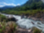
Sometimes, the water level at the Wenshui River (泰安汶水溪) can get pretty high after a typhoon. The water levels in Taiwan's rivers can vary vastly from one visit to the next! Take a look at this, and some of the pictures below, and you'll get a good idea for just how big of a difference it really can be.

The water levels in Taiwan's rivers can vary vastly from one visit to the next! Take a look at this, and some of these pictures and you'll get a good idea for just how big of a difference it really can be.

Take a look at this picture, what do you see? Look at the farthest point on the river... see it there? That's the first really great place we're going to see today! It is...

...Dashimen Waterfall (大石門瀑布)! This is a great place. It's a lot of fun and, if you're careful, it can be really exciting as well. Take a look at the picture above, and then the one below. You might be forgiven for thinking they were two completely different places, right? The photo above was taken in 2021 after a typhoon passed by. The water was so high that jumping (below) or even swimming here was completely impossible... and that was for me, a very good swimmer.

This picture, on the other hand, was taken at the height of a historic drought in 2020. The water was so low that people were literally camping on the river bed! Sure this area is often exposed and dry, but rarely enough for more than one or two people to stand on at the same time. That day it wasn't good for jumping either... but this time it was because the water was too shallow. It was still a great place for a swim, though!

One of our friends gets ready for a swim at Dashimen Waterfall
Swimming and jumping at Dashimen Waterfall in Taian (泰安大石門瀑布) can be a ton of fun, and there's a pretty good high jump when water levels are right. People even waterslide right over the back waterfall! If you're going to do the jump, though, you need to be more careful than at some other places. It's always absolutely essential to check the depth and current before a big jump, no matter how many times you've done it before. You wouldn't believe the amount of rock that can wash in after a typhoon, or just how much more shallow it can be at low water. But here, there's even more to watch out for.

Once you've checked all of that, make sure to pay attention to where the big boulder in the middle of the jumping area is. That's right, there's a huge boulder just under the water in what would otherwise be the best part of this pool for jumping. It's so close to the surface that you can swim over to it and stand up! It's easy enough to make a safe jump between that rock and the waterfall, but just be sure to note where it is before you try.

Starting up the jungle path that leads straight from Dashimen Waterfall to Shuiyun Waterafall
Now that we're done at this small, but beautiful, jungle waterfall, it's time to head on towards the main attraction. There are several ways to get from here to Shuiyun Waterfall. The first is to river trace the whole way. It's fun, as long as you're prepared. The second is a path that basically follows the river along and includes several river crossing / river tracing sections. The third, which we will be following today (and which is on the map and in the GPX track), is to follow a path around this entire section of river, right through the jungle, that takes us straight to the waterfall itself. For the inexperienced, and those with young children, this is definitely the way to go!

Even on this jungle path, which completely avoids the river, conditions are very different depending on the water levels. Usually it's completely dry like the picture above. But sometimes, especially after heavy rain, there's a whole new stream that comes cascading down in an ephemeral waterfall. The first time I ever saw it was, actually, the same trip when I took the high water pictures of Dashimen (above) and Shuiyun (further below). The trail was in such bad shape after the storm, and the water levels were so high, that I had to bushwhack through a whole section that is normally easy to pass through. It seemed almost as if it had never been walked on before!

Now, I had been really hoping to trace past Shuiyun that day, but when the water is that high, there's really no reasonably safe way for a single tracer without specialized gear to get past it. But when I discovered this waterfall on the way back, and took a look on my Outdoor Active GPS tracking app, I realized that the river went right up the side of Tiger Mountain and met with the hiking trail above. That settled it - if I couldn't get past Shuiyun and on to the deeper river tracing areas (more on those in the next few articles), then I was going right up this 'new' river while it was still there to be traced!

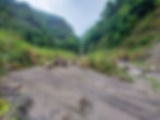
Four pictures of the river just where you cross over to get to Shuiyun waterfall. Can you see the difference in water levels?

A tempting, but not altogether safe, campsite, right at the crossing to Shuiyun Waterfall

It was an amazing adventure! Once I got to the end of the river, I continued along the hiking trail up and over Tiger Mountain and found an untouched, but perfect, campsite. Imagine a forest of truly gigantic, moss-covered trees carpeted in glowing mushrooms with fireflies flying all around you and stars peeking out from between the leaves of the canopy high above as you relax beside a campfire next to the tent you just hiked and traced right up the side of a jungle mountain... and you have this paradise
all...
...to...
...yourself.
It's an experience I will never forget!
The far safer, and more private, campsite just a couple minutes downstream from the crossing
But that was a mountain adventure, and this is river tracing, so back to the Wenshui River!
Sometimes you will find people camping just under the cliff (in the four pictures of the crossing to Shuiyun, just above), just before you cross over to the waterfall. However, there's a decent chance of rockfall here, and several of our team have seen this at various times - and not only in less than perfect weather. We strongly recommend that you backtrack just a few minutes along the riverside from that point to camp at the site in the picture above instead. It's not only much further from potential rockfall, but higher in case of sudden flooding as well.

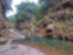
Two pictures of Shuiyun Waterfall taken from almost the exact same spot. Can you tell which was during the drought, and which was after a typhoon?

Cross the river and, at last, here we are - the beautiful, and famous, Shuiyun Waterfall! This place is truly amazing, and deserves its fame and reputation! But despite what it might seem like from this post, it doesn't take very long at all to get there. As I mention below in the Nitty-Gritty section, I can easily get all the way there from the bridge in only 30 minutes one way (1 hour round trip, plus time to enjoy the area), but you may want to double or even triple that if only just to spend more time having fun. But to be honest, why even bother? Just come in the morning, plan to spend the day at Dashimen and Shuiyun, bring some food and friends (and even your children!), and just hang out and have a nice time!


Enjoying Taian's beautiful Shuiyun Waterfall (享受美麗泰安水雲瀑布)

Evening at Shuiyun (水雲瀑布之黃昏)

So now, it's finally time to head on back for the day. Do you remember when you looked carefully at the end of the boardwalk trail on the way in, way back before we had even gotten as far as Dashimen Waterfall? Well, in case you're worried, there are some good markers as you go back. They're easy to miss, but if you're paying attention, you can also easily spot them! Once you're almost out, watch carefully for the rock above. Then, watch for the one below.
Then, just after the two rocks above, look for this or a similar cairn (rock pile). That's where you need to go right in order to go back the way you came.


Don't worry too much if you miss them, though. Just follow the river for a few minutes and you'll find an easy and obvious way out right under the bridge. You have to cross over and get wet of course, but hey - if you haven't gotten wet yet, then something's very, very wrong! No matter which way you end up going out, though, you can try the other one the next time around. After all, Dashimen and Shuiyun are just too magical to only ever come out and visit once... and they're only the tip of the iceberg. There's so much more to explore when you spend time in Taian Outdoors!

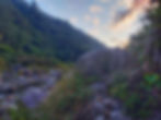
Sunset on the Wenshui River in Taian, near Shuiyun Waterfall (泰安汶水溪水雲瀑布之日落)
THE NITTY-GRITTY
Time:
MY speed: 30 minutes one way (1 hour round trip, plus time to enjoy the area), but you may want to double that.
Water sources:
Before Shuiyun Waterfall, you should probably bring your own, due to the fact that this is a popular and highly trafficked destination.
After that, you can generally rely on the river. Be sure to see the notes on water, though (below)!
Honestly, it's worth considering bringing your own water for this one.
Gear and provisions:
River tracing-appropriate shoes and clothes (see remarks), waterproof backpack, life jackets for anyone who is not a strong swimmer, water (above) or a water filter or other treatment options (see below), a waterproof headlamp or flashlight, a lighter (always!). A basic rope may also be useful for groups with individuals whose swimming abilities are not well developed. Helmets optional.
Sun protection:
Definitely
Yes, if you are an outdoorsy family, unless of high water conditions. One of The Map Room's Team (a father of 4) has taken 3 month old babies to the entrance of Shuiyun Falls (not across) and as young as 3 years to the actual falls. Be sure to take the path referenced in this post, though, it will be much easier. It goes through the jungle and shortens the trip by 5-10 minutes.
Dog friendly:
Yes, though crossing from the last area to the waterfall itself may be slightly tricky.
Camping /overnighting options:
See below, and the points indicated in the GPX track.
GPX file: Taian Outdoors 3-4 Shuiyun Waterfall and Campsite - The Map Room 泰安戶外3-4-水雲瀑布-綠營地-地圖寶庫.gpx


Check out the Map Room Members' Area for more maps, GPX links, and other members only perks!
Remarks:
Parking:
There is a front parking lot with a road leading further into a back parking area. Just drive past the front area, past the guard house, and park at the back parking lot, it will save you a lot of unnecessary walking!
Water:
For this hike, I personally drink 1 or more liters per day in winter, 1.5 or so in summer, but I drink a lot of water and you may drink less than me. It's better to have extra than too little, though.
River tracing gear and provisions (for basic not requiring rappelling and rock climbing skills and gear):
Clothes (tracing): Should be ok for swimming and getting dirty/torn, protect from scrapes. Quick drying, non-cotton, close fitting. UV reflective for hot traces, wetsuit for colder traces.
Boots: Neoprene or other river tracing specific boots (not shoes, NOT rubber or fishing boots!) to prevent blisters. High tops to keep stones out, soles to provide good grip and prevent slipping. I prefer felt soles for extra padding, especially after prior injuries. Some prefer alternatives which prevent organisms from being transferred between various streams and rivers.
Helmet: Designed for rock climbing.
Backpack: Waterproof. IPX 8 rating (protected when immersed in water over 1 meter / 3 feet) recommended.
Rope: Non-climbing rated, floating rope (that does not absorb water and get heavy) with knots is helpful, but NOT for doing serious climbs. Use ONLY for pulling weaker swimmers through more challenging stretches of water, and perhaps helping with scrambles up short sections of difficult terrain. For advanced climbing or rappelling, get advanced climbing rope, gear, and training!
Life jacket: If you are not a strong and confident swimmer.
Phone case: IPX 8 rating (protected when immersed in water over 1 meter / 3 feet) recommended.
Water filter or other water treatment options.
Waterproof headlamp or flashlight. IPX 8 rating (protected when immersed in water over 1 meter / 3 feet) recommended.

The Map Room recommends Fenix headlamps for high-quality, durable headlamps for hiking and river tracing (Amazon affiliate link*).
Lighter (always!)
Optional gear: A bandanna, headband, or other light cloth for wiping sweat is also often useful when you are not fully immersed in water.
Drinking water:
Choose water from a fast moving, clean source. This kills certain parasites, like giardia. Check upstream for polluting factors (dead animals, droppings, etc). Look for signs of pollution (vehicle tracks, lots of footprints). It's best to filter, and possibly either boil or otherwise treat it as well.

The Map Room personally uses and highly recommends the Sawyer Squeeze water filter (NOT the Sawyer Squeeze Mini - Amazon affiliate link*)
Important safety notes for river tracing in Taiwan (and elsewhere):
Strength and water levels of rivers change with rain, seasons, and other factors.
ALWAYS check the weather in advance of a river trace in Taiwan (or anywhere). If there is rain upstream, it is not advisable to go, due to the risk of flash floods.
If it has rained recently, rockslides are more likely. If the sun then comes out and evaporates recent rain, they are more likely still. Wear a helmet, and be sensible!
Stopping to rest in rockfall areas, under rock overhangs, or near sheer cliffs is not advisable due to the risk of rockfalls. Look for a wider, open area with less steep rock walls.
So now you're ready to go! Get out there, enjoy nature, be active, and have an amazing time!
Ready to learn more about the Taian area? Check out the whole series here!
Got questions or comments? Can you think of something we missed? Join in the discussion and leave a comment below. At the end of the day, we're just outdoors enthusiasts like you, and we'd love to hear from you!
All information on this page is intended for reference only. Preparing adequate food, water, and gear for your adventure, as well as following local rules and laws are, of course, your own responsibility! Always make sure that you check the weather for outdoor destinations, be careful and sensible for enclosed spaces like tunnels and bunkers, and bring a lighter - you never know when it could save your life! Now... get out there and have an amazing time!

10% discount on Parkbus Taiwan! Click the link and enter the discount code MapRoom10 for a 10% discount on Parkbus Taiwan rides!
The Map Room has an affiliate arrangement with Parkbus Taiwan and will receive a commission if you do. We stand strongly by our affiliates, because at the end of the day, they help get us safely to the end of the day.

Click the link above to get 20% off a year-long, premium Gaia GPS tracking and route planning subscription! The Map Room has an affiliate arrangement with Gaia and will receive a commission if you do... but we ONLY recommend products that we have tested, used, and loved in the field ourselves! We stand strongly by our affiliates, because at the end of the day, they help get us safely to the end of the day.

Hi! You love the outdoors and so do we! Please help support The Map Room so we can keep helping you do what we love to do!
*Please note that The Map Room participates in the Amazon Associate Program, and other affiliate programs. Some of the links on The Map Room may refer to Amazon or our other affiliates, and as a member of these, The Map Room will receive a commission at no additional cost to you. We ONLY endorse products we ourselves use, have used, or would use personally!