.png)
Taian Outdoors 1: Tiger Mountain, Taian's Forgotten Mountain (泰安戶外1:失落的虎山)
- The Cartographer
- Jan 5, 2022
- 11 min read
Updated: Apr 27, 2024

INDEX
Welcome to The Map Room's Taian Outdoors series!
This is the first in a series of articles about the Taian area in Miaoli, Taiwan. River tracing Shuiyun and many other waterfalls and hiking Tiger Mountain and Jialishan (Jiali Mountain) are just some of the amazing adventure sports experiences in this little known and often overlooked corner of Taiwan!
Hikes and river traces in this series:
Taian Outdoors 1: Tiger Mountain, Taian's Forgotten Mountain (泰安戶外1:爬虎山) Beginner - Intermediate
Taian Outdoors 2: Backdoor to Jiali Mountain: Tiger Mountain (泰安戶外2:加里山秘境入口:虎山) High Intermediate
Taian Outdoors 3: Beautiful, and Dangerous, Nature in the Taian Area! (泰安戶外3:美麗,又險峻,的泰安大自然!)
Taian Outdoors 4: Hiking and River Tracing to Shuiyun Waterfall (泰安戶外4:爬山和溯溪去水雲瀑布) Novice
Taian Outdoors 5: River Tracing Past Shuiyun to a Huge Waterfall (with guest writer, Renegade Tourist) (泰安戶外5:溯溪過水雲到一個大瀑布) Intermediate
Taian Outdoors 6: River Tracing Past Shuiyun to a Tall, Double-Decker Waterfall! (泰安戶外6:溯溪過水雲到一個大,雙層瀑布) Advanced
Taian Outdoors 7: River Tracing Above Shuiyun to Monkey Falls! (泰安戶外7:繞水雲溯溪到猴子瀑布) Advanced
Wrestle with roots and ropes as you wrangle right up this rough, rocky route to the ridge. Think that's hard to say (or even to read)? I guarantee you it's a lot easier than actually doing it!
*Please note that The Map Room participates in the Amazon Associate Program, and other affiliate programs, and may earn from qualifying purchases at no extra cost to you.
Introducing this week's adventure:
Taian Outdoors 1: Hiking to Tiger Mountain
(泰安戶外1:爬虎山)

The distinctive, horn-like peak of Tiger Mountain (虎山) as viewed from the parking area
Say the name Taian (泰安), and hiking may not be the first thing to jump to most people's minds. Beautiful Shuiyun Waterfall (水雲瀑布) - one of the best, and easiest to visit, waterfalls in northwestern Taiwan - tends to get all the attention. But did you know Taian is also home to a much less well known, but still beautiful, day hike - and that it doubles as a back door to Jiali Mountain (Jialishan / 加里山)? Yes, that's right, there are not one, not two, but three different ways to get to Jialishan, and of them all, this is the one you are probably least likely to have ever thought or heard of. Intrigued? Well then, keep on reading!
View from Shuiyun Suspension Bridge (水雲吊橋) after heavy rains. There's a whole extra waterfall right there!

Tiger Mountain (虎山) in Miaoli's Taian (苗栗泰安) is an often overlooked, but beautiful, mountain in Taiwan (台灣). At 1492 meters (4895 ft.), it can be a good, beginner-friendly day hike, taking 3-5 hours to cover the 896 meters (2940 feet) of elevation gain over 3 km. of trail. For more fit and experienced challengers, it can also serve as the back door for a more challenging approach to Jialishan (Jiali Mountain / 加里山) over the much less visited Dujuanling Mountain (杜鵑嶺山).

The route to Tiger Mountain starts out just the same as going to Shuiyun Waterfall. First, cross the Shuiyun Suspension Bridge (水雲吊橋) over the Wenshui River (汶水溪). It's a beautiful bridge with great views of the river that change with the ebb and flow of the river.

Shuiyun Suspension Bridge (水雲吊橋) at sunset

Head on up the stairs...

...and after about five minutes, you will get to this rest area.

This, however, is where the two routes part. Rather than going down, you need to head up when you see this sign.

Taking it easy at the foot of Tiger Mountain
When we visited, we decided to take it nice and easy. We set up a tent in this nice, cozy, and very small campsite just about one minute's walk up the trail to Tiger Mountain. It's just on the right, and since most people only come here for day hikes or to visit the waterfall, there's a decent chance that nobody will be camping there.

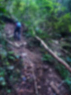
The path itself starts off pretty easy, if you're basically in shape and have any experience with hiking in the foothills. While the first 10-20 minutes are a bit steep, it soon flattens out and becomes a gradual, gentle uphill. It's a great chance to enjoy some beautiful, near-tropical jungle scenery, and a nice warmup for what's to come.

A gentle uphill slope dominates the first part of the trail. Enjoy it while you can - it won't last long!

Then, right around 2.3 km from the bridge, everything suddenly changes. It took us just under an hour at a relaxed pace to get to that point, and we had only gained about 600 or so meters of elevation to that point. Then, it was straight uphill, with a gain of almost 400 meters over only 800 meters of trail. In other words, it got really steep, really fast!
Alice climbs a rope section on the way to Tiger Peak
This second section - all the way to the top - is much more challenging, and a lot of fun! If climbing ropes, scrambling up long sections of tree roots like ladders, and working up a good sweat, all on the way to an amazing view of the Wenshui River Valley and distant Shuiyun Waterdfall sounds like your idea of a good time, then this is definitely the place for you!

Wrestle with roots and ropes as you wrangle right up this rough, rocky route to the ridge. Think that's hard to say (or even to read)? I guarantee you it's a lot easier than actually doing it!

Mist settles in as we continue our climb. Fog and clouds come and go fast on Tiger Mountain - so don't worry if you blink and miss that great, blue sky view, just wait five or ten minutes and the mountain may well change its mood again...

But don't let me give you the wrong impression, this isn't just some nasty, grueling, super-challenging uphill. Tiger Mountain, and the whole Taian area, are home to some amazing nature. In fact, there's so much beauty and variety that it's going to take a whole, dedicated blog post to do it justice! Just to give you an idea, though, here are some of the things we've seen on this trail.

This beautiful, twisted, spiraling tree is one of my favorite features hiking up Taian's Tiger Mountain


Johan stares down the legendary - and deadly - hundred pace snake (百步蛇)
On one of our visits my friend Johan, from Discover Taiwan with Johan, and I suddenly encountered one of the most mysterious and difficult animals to see in the lower altitudes of Taiwan. A deadly hundred pace snake (百步蛇) - so named because you are bitten you are said to have one hundred paces until your death - was coiled up right there in the middle of the trail! The snake, the most poisonous animal in Taiwan and arguably one of the deadliest creatures in the world, seemed just as surprised to see us as were to see it. These guys usually come out at night, but for some reason this adolescent specimen was just lounging around on the trail in the middle of the morning when suddenly it saw two monstrous creatures that must have looked to it about the size of Taipei 101 come walking around a corner and start making all kinds of weird gestures and noises. I can only imagine it must have been terrified!

The hundred pace snake (百步蛇) holds a special and sacred place the religion and traditions of certainly Taiwanese Aboriginal tribes Check out this great article from The Map Room's friend, Snakes of Taiwan, to learn more!
We stopped there in our tracks and, once it became clear that the snake was not going to do anything to us unless we provoked it first, we decided to take a cautious look from a respectful distance. After a couple minutes, a few photos, and a feeling of awe at the unique, deadly beauty we had encountered, we decided it was time to break the impasse. I slowly extended my hiking pole to its longest length - well over a meter - and gently tapped the snake, carefully guiding it to the side of the trail. Once there, it slithered down the mountainside into the jungle and everyone involved in the encounter - mammal and reptile - was able to relax a little bit and go on about their respective days in peace.

The sign post at the top of the hike. The peak is just an easy five minutes walk further on!
Nature can beautiful and you never know what you'll see when you hike a trail through the mountain jungles of Taiwan. But the trail itself - and the peak above - were still calling. We resumed our hike, and after a good amount of sweat and exercise, we finally reached the goal we had been working towards!

Standing at the signpost at the top of the uphill section of the hike

Standing at the top of Tiger Mountain is an amazing feeling - especially if you've ever visited Shuiyun Waterfall or done any river tracing in Taian's Wenshui River area. There are beautiful views of the waterfall, the valley, and the mountains beyond. It might take a bit of work to get there, but the views, and the feeling of standing there at the top, are definitely worth it!


So that's as far as we're going today. The trail goes ever on and on, and for the more ambitious the peak of Tiger Mountain is only the beginning. From here, you can continue on over Dujuanling Mountain (杜鵑嶺山) and continue all the way to Jiali Mountain (Jialishan / 加里山), but that's a much more serious, and advanced, hike, and a story for another day. We will visit there soon, but for today, let's stop here, enjoy the view, and look forward to the next adventure!
THE NITTY-GRITTY
Skill level:
Beginner, though there is one section where you have to walk across a short section of rockslide with the aid of a rope (already in place).
Length of hike:
3 km there and back
MY Time:
3 hours or so on average, round trip.
Ascent:
896 m
IMPORTANT: I am very fast, and even though I wasn't moving particularly quickly on this trip, it might be worth planning 4+ hours, round trip, for this hike.
Water sources:
Dayhike:
You can get water from the creek on the way, in, but it should be filtered and boiled or treated due to the high volume of hiking traffic in the area. Honestly, you're much better off just bringing your own water on this part of the hike (and perhaps just the whole thing, to save trouble).

The Map Room personally uses and highly recommends the Sawyer Squeeze water filter (NOT the Sawyer Squeeze Mini - Amazon affiliate link*)
Overnight:
Water available at the headwaters OFF THE TRAIL (use caution leaving the trail - see GPX, map)
Gear and provisions:
Good hiking shoes, hiking-appropriate clothes (see remarks), enough water (see above), a lighter (always!), a headlamp or flashlight, lunch and snacks. Hiking poles highly recommended.

The Map Room recommends Fenix headlamps for high-quality, durable headlamps for hiking and river tracing (Amazon affiliate link*).
Sun protection:
Not generally necessary on this well-shaded, forested hike.
Yes for teenagers 15 or older in good physical condition (this will likely be strenuous for them). Adults in less than good physical condition will find this hike strenuous as well.
Dog friendly:
Possibly, if your dog is experienced with serious uphills. You may need to help it over branch / rope sections. Use careful judgement.
Camping /overnighting options:
Though Tiger Mountain is best taken as a day hike, there are nevertheless several potential overnight options. The most useful are:
Small campsite (2 tents) one minute's walk above the rest area (no water source)
Various places around the top of the mountain (no water source)
Campsite about 20 minutes further past Tiger peak (not necessarily suitable for heavy rain conditions, as heavy rain tends pool in the area). It's at the end of this GPX track.
Taian Outdoors 1 Tiger Mountain Taian's Forgotten Mountain - The Map Room (泰安戶外1:失落的虎山) - 地圖寶庫.gpx


Check out the Map Room Members' Area for more maps, GPX links, and other members only perks!
Remarks:
Parking:
There is a front parking lot with a road leading further into a back parking area. Just drive past the front area, past the guard house, and park at the back parking lot, it will save you a lot of unnecessary walking!
Clothes:
Regardless of the hike, it ALWAYS pays off to have appropriate hiking clothes! These should be clothes you don't mind getting dirty and/or messed up. Pants, shirts, socks, and underwear should all be quick wicking to get sweat off of your skin and quick drying to get it off of your clothes. For these reasons, you should NEVER wear cotton hiking! Sports pants and a sports shirt are a good place to start, but hiking pants have many advantages. A bandanna, headband, or other light cloth for wiping sweat is also advisable.
Water:
For this hike, I personally drink 1.5 liters per day in winter, 2 in summer, but I drink a lot of water and you may drink less than me. It's better to have extra than too little, though.
So now you're ready to go! Get out there, enjoy nature, be active, and have an amazing time!
Ready to learn more about the Taian area? Check out the whole series here!
Got questions or comments? Can you think of something we missed? Join in the discussion and leave a comment below. At the end of the day, we're just outdoors enthusiasts like you, and we'd love to hear from you!
All information on this page is intended for reference only. Preparing adequate food, water, and gear for your adventure, as well as following local rules and laws are, of course, your own responsibility! Always make sure that you check the weather for outdoor destinations, be careful and sensible for enclosed spaces like tunnels and bunkers, and bring a lighter - you never know when it could save your life! Now... get out there and have an amazing time!

10% discount on Parkbus Taiwan! Click the link and enter the discount code MapRoom10 for a 10% discount on Parkbus Taiwan rides!
The Map Room has an affiliate arrangement with Parkbus Taiwan and will receive a commission if you do. We stand strongly by our affiliates, because at the end of the day, they help get us safely to the end of the day.

Click the link above to get 20% off a year-long, premium Gaia GPS tracking and route planning subscription! The Map Room has an affiliate arrangement with Gaia and will receive a commission if you do... but we ONLY recommend products that we have tested, used, and loved in the field ourselves! We stand strongly by our affiliates, because at the end of the day, they help get us safely to the end of the day.

Hi! You love the outdoors and so do we! Please help support The Map Room so we can keep helping you do what we love to do!
*Please note that The Map Room participates in the Amazon Associate Program, and other affiliate programs. Some of the links on The Map Room may refer to Amazon or our other affiliates, and as a member of these, The Map Room will receive a commission at no additional cost to you. We ONLY endorse products we ourselves use, have used, or would use personally!